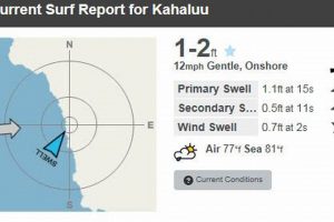
Wave conditions can be challenging to predict. Technological aids are employed to provide detailed analyses of ocean swells and wind patterns. These tools, often located at strategic coastal points, transmit real-time data regarding wave height, period, and direction. For example, a buoy stationed offshore collects and sends data used to generate forecasts.
Accurate information is crucial for surfer safety and enjoyment. Reliable data enables informed decisions about when and where to engage in the sport. This has led to a significant advancement in ocean monitoring techniques, providing greater insights into marine environments, contributing to safety and improved recreational opportunities.
The following sections will detail the specific types of equipment used, the interpretation of the data they provide, and how this information is utilized by surfers and coastal communities.
Utilizing Data from Coastal Monitoring Systems
Successful use of swell information requires a comprehensive understanding of its components and how to apply it to surf forecasting. The following guidelines facilitate that process.
Tip 1: Understand Data Components. Analyze wave height, period, and direction. Wave height indicates size, period reflects power, and direction shows approach angle.
Tip 2: Differentiate Between Swell and Wind Waves. Swell is generated by distant storms, creating organized lines. Wind waves, produced locally, are often choppy and disorganized.
Tip 3: Consult Multiple Sources. Compare readings from various coastal monitoring systems for a more comprehensive overview. Discrepancies may indicate localized conditions.
Tip 4: Analyze Tidal Influences. Understand how tides impact wave shape and breaking patterns. High tides can soften waves, while low tides may cause them to break harder and faster.
Tip 5: Assess Local Bathymetry. The ocean floor’s shape significantly affects how waves break. Reefs, sandbars, and points can create varied wave types and conditions.
Tip 6: Consider Wind Conditions. Offshore winds can groom waves, creating cleaner, more defined shapes. Onshore winds tend to disrupt wave formation.
Tip 7: Account for Seasonal Variations. Be aware that wave patterns often change seasonally. Winter months may bring larger swells, while summer months typically offer smaller, more consistent waves.
Effective interpretation of conditions enhances awareness and promotes safer and more enjoyable surfing experiences. Skillful analysis enables informed decisions about surf spot selection.
The subsequent segment will focus on the practical application of this knowledge in real-world surfing scenarios.
1. Real-time data availability
Real-time data availability forms a fundamental component of effective wave condition dissemination systems. Without up-to-the-minute information on wave height, period, and direction, these tools become significantly less useful. The delay, even of a few hours, in providing data can misrepresent current conditions, leading to potentially hazardous situations for surfers and other water users. For example, a sudden increase in swell size due to a distant storm could be missed if relying on outdated data, placing individuals at risk.
This immediacy is achieved through a combination of technologies, including sensor-equipped buoys strategically placed offshore, and land-based radar systems. Data collected are transmitted wirelessly to central servers and processed for immediate display on websites and mobile applications. The reliability of this transmission is paramount; redundancies in power sources and communication channels are often implemented to minimize downtime. The speed of data processing and delivery is further optimized through advanced algorithms, ensuring users receive timely and accurate assessments of current wave conditions.
In summary, the value of wave condition dissemination systems is intrinsically linked to the promptness of data availability. This real-time component enables surfers and coastal communities to make informed decisions, mitigating risk and maximizing enjoyment of the ocean. The ongoing development of faster, more reliable data transmission methods remains a critical area of focus for improving coastal safety and enhancing recreational opportunities.
2. Wave parameter measurement
Wave parameter measurement is integral to the functionality of surf reporting systems. These systems depend on precise data regarding wave height, period, direction, and water temperature. Inaccurate or absent data renders the reporting system ineffective, potentially leading to misinformed decisions by surfers and coastal authorities. The relationship between these measurements and the reports is one of cause and effect; the accuracy of the former directly determines the utility of the latter. For example, if a buoy inaccurately reports a wave height of 1 meter when it is actually 2 meters, surfers may underestimate the risks, leading to dangerous situations.
The practical application of accurate wave parameter measurements extends beyond recreational surfing. Coastal engineers rely on this data for shoreline protection projects, while maritime industries use it for navigation and safety. Consider the impact of Storm X, where accurately reported wave heights allowed port authorities to prepare in advance, preventing significant damage to infrastructure. Conversely, inadequate data during Hurricane Y led to unexpected flooding and extensive property damage, demonstrating the real-world consequences of reliable wave parameter measurement.
In conclusion, precise wave parameter measurement forms the bedrock of effective surf reporting. The challenges lie in maintaining the accuracy and reliability of these measurements in dynamic marine environments. As technology advances, improved sensors and data processing techniques are constantly sought to enhance the precision and availability of this critical information, fostering safer and more informed interactions with the ocean.
3. Geographic location specificity
Geographic location specificity is paramount in the efficacy of coastal monitoring systems. The utility of these systems is directly proportional to the accuracy with which they represent wave conditions at a particular location. Generalized information lacks the necessary granularity for informed decision-making, potentially leading to inaccurate assessments and increased risk.
- Resolution and Accuracy
The resolution of a coastal monitoring system determines its ability to capture localized variations in wave conditions. Higher resolution systems, often employing multiple monitoring points, provide a more detailed representation of the surf environment. For example, a system utilizing a single buoy several kilometers offshore cannot accurately reflect the nuances of wave behavior near a specific reef break. Such generalization can mislead surfers regarding wave size and shape.
- Topographical Influences
Coastal topography significantly influences wave behavior. Features such as reefs, points, and sandbars interact with incoming swells, modifying their characteristics. Monitoring systems must account for these local effects to provide accurate information. Systems that fail to consider these topographical influences may report wave conditions that are not representative of the actual surf available at specific locations. This is particularly crucial for areas with complex coastal geography.
- Temporal Variability
Wave conditions exhibit temporal variability, changing rapidly due to shifting wind patterns and swell propagation. Monitoring systems must provide real-time data updates to capture these fluctuations. Geographic location specificity becomes even more important when considering temporal variability. Conditions at one location may shift dramatically while remaining relatively stable at another nearby location. Frequent data updates are essential for accurate representation.
- Calibration and Validation
Calibration and validation are critical for ensuring the accuracy of data provided by coastal monitoring systems. This process involves comparing system readings to actual wave conditions observed at the monitored location. Discrepancies are identified and corrected, improving the overall reliability of the system. Regular calibration is essential, as environmental factors can impact sensor performance over time. Geographic location specificity necessitates site-specific calibration protocols.
In summary, geographic location specificity is integral to the effectiveness of coastal monitoring systems. Accurate representation of wave conditions requires high-resolution systems, consideration of topographical influences, frequent data updates, and rigorous calibration protocols. Systems that prioritize geographic location specificity provide surfers and coastal communities with the reliable information needed to make informed decisions and mitigate risks.
4. Technological accuracy reliability
The operational effectiveness of wave condition dissemination systems hinges critically on the technological accuracy and reliability of the equipment deployed. Data integrity is paramount, given the potential for flawed information to lead to misinformed decisions with significant safety implications. Technological accuracy refers to the ability of the instruments to precisely measure wave parameters. Reliability, conversely, speaks to the consistency and dependability of these measurements over time, despite challenging environmental conditions. The cause-and-effect relationship is clear: compromised accuracy or diminished reliability will invariably degrade the value of the surf reports generated by these systems. Consider, for instance, a buoy utilizing a faulty accelerometer; the resulting wave height estimations would be inaccurate. Similarly, a system prone to frequent communication failures due to unreliable telemetry cannot provide the consistent, real-time updates necessary for informed decision-making.
The importance of technological accuracy and reliability extends beyond the immediate safety of surfers. Coastal engineers, for example, utilize wave data for shoreline protection projects and infrastructure design. Marine industries rely on accurate forecasts for navigation and operational planning. The economic ramifications of inaccurate data can be substantial. The aforementioned buoy serves as an informative illustration. In the instance of Storm X, a failure in the wave period sensor resulted in an underestimation of wave energy, leading to inadequate preparations and subsequent damage to coastal structures. Conversely, during Storm Y, the deployment of upgraded, more reliable sensors provided accurate and timely warnings, enabling effective mitigation measures and minimizing losses.
In conclusion, technological accuracy and reliability form an indispensable foundation for the efficacy of surf reporting systems. The integrity of the data they provide is crucial for safety, economic stability, and informed coastal management. Continuous investment in advanced sensor technologies, robust communication infrastructure, and rigorous quality control protocols is essential to ensure the sustained value and reliability of these vital information systems. The ongoing challenge lies in maintaining high standards of technological performance in the face of dynamic and often harsh marine environments.
5. Community safety enhancement
Coastal communities benefit significantly from the presence and reliability of wave condition dissemination systems. Accurate and accessible surf reports, derived from strategically positioned sensors, directly contribute to the reduction of water-related incidents and improved emergency response capabilities. The connection between these systems and community safety is one of proactive risk management; by providing real-time information about wave conditions, these systems enable individuals and organizations to make informed decisions, avoiding potentially hazardous situations. The absence of reliable reporting mechanisms increases the likelihood of accidents, particularly among inexperienced water users who may misjudge the prevailing conditions.
Examples of this connection are readily found in coastal regions worldwide. Consider the coastal town of “A,” which implemented a comprehensive wave monitoring system coupled with public awareness campaigns. Following the implementation, the number of rescue operations decreased by 40% within two years. Conversely, in the neighboring town of “B,” which lacked similar systems, the incident rate remained consistently high, highlighting the tangible impact of accessible wave data. Emergency response teams also rely on these reports to plan and execute rescue operations more effectively. Knowing the precise wave height, period, and direction allows responders to assess the risks involved and deploy resources accordingly, improving the chances of successful rescues and minimizing the danger to rescue personnel.
The enhancement of community safety through accurate and reliable surf reports is a practical application of technology that yields measurable benefits. Ensuring the continued investment in and maintenance of these systems is crucial for protecting lives and promoting responsible ocean use. Challenges remain, particularly in remote or underserved coastal areas, where access to these technologies may be limited. Addressing these disparities requires collaborative efforts between government agencies, research institutions, and local communities to ensure that the benefits of wave condition monitoring are available to all.
Frequently Asked Questions
The following addresses common inquiries concerning the function, benefits, and limitations of surf report beacons and their integration within coastal safety and recreational activities.
Question 1: What are the primary functionalities of surf report beacons?
The primary functions encompass the real-time measurement and transmission of key wave parameters, including wave height, period, direction, and water temperature. This data is then utilized to generate forecasts accessible to surfers, coastal communities, and maritime industries.
Question 2: How is the data from these beacons collected and transmitted?
Typically, data collection is achieved through sensor-equipped buoys or land-based radar systems strategically positioned along coastlines. The data is transmitted wirelessly via radio waves or satellite communication to central servers for processing and dissemination.
Question 3: What factors can affect the accuracy of surf report beacon data?
Several factors can influence accuracy, including sensor malfunction, inclement weather conditions, interference with data transmission, and improper calibration. Routine maintenance and quality control protocols are essential to mitigate these influences.
Question 4: How frequently is the data updated in surf reports generated by these beacons?
The update frequency varies depending on the system but generally ranges from every few minutes to hourly. Real-time or near real-time updates are critical for providing timely and relevant information to water users.
Question 5: Are surf report beacons accessible to the general public, or are they restricted to specific user groups?
Most surf report beacons provide publicly accessible data via websites or mobile applications. However, some specialized data may be restricted to researchers or commercial users.
Question 6: What are the limitations of relying solely on surf report beacon data for assessing wave conditions?
Surf report beacons provide valuable data but should not be the sole basis for decision-making. Local knowledge, visual observation of wave conditions, and understanding of tidal influences remain essential for a comprehensive assessment. Reliance solely on technical data without contextual awareness may lead to misinterpretations.
In summary, while providing real-time measurements, the integration of diverse methods alongside local knowledge ensures a more comprehensive understanding of maritime conditions.
The succeeding segment will explore best practices for equipment maintenance and system redundancy.
Conclusion
This exploration of surf report beacons has illuminated their crucial role in providing real-time data on wave conditions. Accurate measurements of wave height, period, and direction, combined with geographic location specificity and reliable technology, are essential for informed decision-making by surfers, coastal communities, and maritime industries. The integration of these systems enhances safety, supports coastal engineering, and contributes to economic stability.
Continued investment in advanced sensor technologies, robust communication infrastructure, and rigorous quality control protocols is paramount. The future requires collaborative efforts to expand access to these vital information systems, ensuring that their benefits extend to all coastal regions. Accurate and reliable information empowers responsible ocean use and fosters a greater understanding of the dynamic coastal environment.


![Get Your Daily Jupiter FL Surf Report: [Conditions Update] Learn to Surf & Skate: A Beginner's Step-by-Step Guide Get Your Daily Jupiter FL Surf Report: [Conditions Update] | Learn to Surf & Skate: A Beginner's Step-by-Step Guide](https://universitysurfandskate.com/wp-content/uploads/2026/02/th-235-300x200.jpg)

![Your Launiupoko Surf Report: [Live] Ocean Conditions & Forecast Learn to Surf & Skate: A Beginner's Step-by-Step Guide Your Launiupoko Surf Report: [Live] Ocean Conditions & Forecast | Learn to Surf & Skate: A Beginner's Step-by-Step Guide](https://universitysurfandskate.com/wp-content/uploads/2026/02/th-202-300x200.jpg)

